Welcome to the Pepper Ridge North Valley's
Severe Weather Page
This is your weather warning resource page. Check this page for the latest watches and warning updates,
from The National Weather Service, Phoenix, Az.!
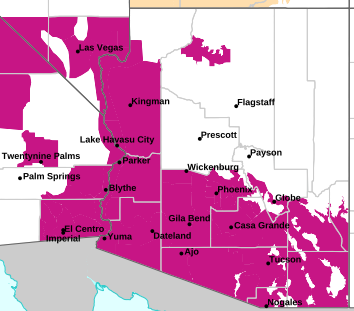
MAP OF CURRENT SOUTHWEST WATCHES, WARNINGS AND ADVISORIES
Local & Regional Weather Statements, Watches And Warnings
Weather Alerts for Eastern & Western Mogollon Rim/White MtnsIssued by the National Weather Service |
 WIND ADVISORY |
| EASTERN & WESTERN MOGOLLON RIM/WHITE MTNS |
Areas Affected:
Little Colorado River Valley in Coconino County - Little Colorado River Valley in Navajo County - Little Colorado River Valley in Apache County - Eastern Mogollon Rim - White Mountains |
| Effective: Sat, 10/31 9:31pm |
Updated: Sun, 11/1 4:16am |
Urgency: Expected |
| Expires: Sun, 11/1 11:00pm |
Severity: Moderate |
Certainty: Likely |
|
Details:
* WHAT...Southwest winds 20 to 30 mph with gusts up to 50 mph
expected.

* WHERE...Little Colorado River Valley, Eastern Mogollon Rim, and
White Mountains.

* WHEN...From 8 AM to 11 PM MST Sunday.

* IMPACTS...Gusty winds will blow around unsecured objects. Travel
will be difficult, especially for high profile vehicles.
Information:
Winds this strong can make driving difficult, especially for high
profile vehicles, such as RVs, campers, and tractor trailers. Use
extra caution.

Secure loose outdoor objects that could be blown around or damaged by
the wind. |
 FLOOD WATCH |
| EASTERN & WESTERN MOGOLLON RIM/WHITE MTNS |
Areas Affected:
Kaibab Plateau - Marble and Glen Canyons - Grand Canyon Country - Coconino Plateau - Yavapai County Mountains - Northeast Plateaus and Mesas Hwy 264 Northward - Chinle Valley - Chuska Mountains and Defiance Plateau - Little Colorado River Valley in Coconino County - Little Colorado River Valley in Navajo County - Little Colorado River Valley in Apache County - Western Mogollon Rim - Eastern Mogollon Rim - White Mountains - Northern Gila County - Yavapai County Valleys and Basins - Oak Creek and Sycamore Canyons - Black Mesa Area - Northeast Plateaus and Mesas South of Hwy 264 |
| Effective: Sat, 10/31 11:14pm |
Updated: Sun, 11/1 4:16am |
Urgency: Future |
| Expires: Sun, 11/1 7:15am |
Severity: Severe |
Certainty: Possible |
|
Details:
* WHAT...Flash flooding caused by excessive rainfall over saturated
soils.

* WHERE...All of northern and central Arizona.

* WHEN...Through late Sunday night.

* IMPACTS...Flash flooding will be possible in creeks, normally dry
washes, swimming holes, and over recently burned areas. Low-water
crossings may be flooded.

* ADDITIONAL DETAILS...
- Rain and isolated thunderstorms are expected Saturday night
through the early morning hours of Monday. An additional 1 to 4
inches of rain will be possible, on already saturated ground.
- Additional information is available at weather.gov/flagstaff.
Information:
Have a way to receive Flash Flood Warnings and be prepared to take
action should warnings be issued.

Consider changing your plans if you were going to hike, boat, or
paddleboard to a slot canyon or normally dry wash. If you do still
decide to recreate, check in at a nearby visitor center or ranger
station. |
| FLOOD WATCH |
| EASTERN & WESTERN MOGOLLON RIM/WHITE MTNS |
Areas Affected:
Tohono O'odham Nation including Sells - Upper Santa Cruz River and Altar Valleys including Nogales - Tucson Metro Area including Tucson/Green Valley/Marana/Vail - South Central Pinal County including Eloy/Picacho Peak State Park - Southeast Pinal County including Kearny/Mammoth/Oracle - Upper Gila River and Aravaipa Valleys including Clifton/Safford - White Mountains of Graham and Greenlee Counties including Hannagan Meadow - Galiuro and Pinaleno Mountains including Mount Graham - Santa Catalina and Rincon Mountains including Mount Lemmon/Summerhaven - Baboquivari Mountains including Kitt Peak |
| Effective: Sun, 11/1 4:10am |
Updated: Sun, 11/1 4:16am |
Urgency: Future |
| Expires: Sun, 11/1 4:00pm |
Severity: Severe |
Certainty: Possible |
|
Details:
* WHAT...Flooding caused by excessive rainfall is possible.

* WHERE...A portion of Southeast Arizona, including the following
areas, Baboquivari Mountains, Catalina and Rincon Mountains,
Galiuro and Pinaleno Mountains, South Central Pinal County,
Southeast Pinal County, Tohono O'odham Nation, Tucson Metro Area,
Upper Gila River Valley, Upper Santa Cruz River Valley/Altar Valley
and White Mountains of Graham and Greenlee Counties.

* WHEN...Through late tonight.

* IMPACTS...Excessive runoff may result in flooding of rivers,
creeks, streams, and other low-lying and flood-prone locations.
Flooding may occur in poor drainage and urban areas. Low-water
crossings may be flooded.

* ADDITIONAL DETAILS...
- A strong weather system approaching the area will bring
widespread  showers today. Moderate to locally heavy rainfall
with rainfall totals 0.5 to 1.25 inches possible in the valleys
and 1 to 3 inches possible in the mountains.
- http://www.weather.gov/safety/flood
Information:
You should monitor later forecasts and be alert for possible Flood
Warnings. Those living in areas prone to flooding should be prepared
to take action should flooding develop. |
Key to Icons for Local & Regional Weather Statements, Watches And Warnings

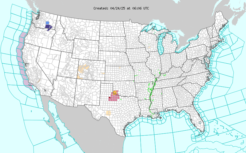
Map of the Current Watches, Warnings, and Advisories Nationwide:
|
|
Member of the:


|
North Valley Random Weather Facts |
HEAT
Although Phoenix residents may feel that their city MUST be the hottest place around at times, the hottest temperatures in the state occur along the Colorado river in cities such as Bullhead City, Lake Havasu City, Parker or Yuma. In fact the top State honors go to Lake Havasu City, where the mercury climbed to 128° on June 29, 1994. This bests the Phoenix mark of 122°, set on June 26, 1990.
Get the Facts PHP
|
|
Page layout last updated on Mar 8th, 2024
|
|
|


 New Feature