Welcome to the Pepper Ridge North Valley's
Severe Weather Page
This is your weather warning resource page. Check this page for the latest watches and warning updates,
from The National Weather Service, Phoenix, Az.!
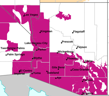
MAP OF CURRENT SOUTHWEST WATCHES, WARNINGS AND ADVISORIES
Local & Regional Weather Statements, Watches And Warnings
Weather Alerts for Yavapai CountyIssued by the National Weather Service |
 FLASH FLOOD WARNING |
| YAVAPAI COUNTY |
Areas Affected:
Yavapai, AZ |
| Effective: Sun, 11/1 1:49am |
Updated: Sun, 11/1 3:11am |
Urgency: Immediate |
| Expires: Sun, 11/1 4:45am |
Severity: Severe |
Certainty: Likely |
|
Details:
FFWFGZ

The National Weather Service in Flagstaff has issued a

* Flash Flood Warning for...
Yavapai County in west central Arizona...

* Until 445 AM MST.

* At 149 AM MST, Doppler radar indicated heavy rain across the warned
area. Between 0.5 and 1.5 inches of rain have fallen. Additional
rainfall amounts of 1 to 2 inches are possible in the warned area.
Flash flooding is ongoing or expected to begin shortly.

HAZARD...Life threatening flash flooding. Heavy rain producing
flash flooding.

SOURCE...Radar indicated.

IMPACT...Life threatening flash flooding of creeks and streams,
normally dry washes, urban areas, highways, streets and
underpasses.

* For Granite Creek at Prescott:
At 1:30am the stage was 10.61 feet.
Flood Stage is 11.0 feet.
Impacts:
At 11.0 feet: Flooding begins at AC Williams Granite Creek Park
upstream of gage. Low lying patios along Granite Creek in downtown
Prescott flood.
...
For Granite Creek at Granite Creek Near Prescott:
At 1:30am the stage was 7.27 feet.
Flood Stage is 11.0 feet.
Forecast: A crest of 10.91 feet is expected at 6:00pm Sunday.
Impacts:
At 11.0 feet: Minor flooding. Lowland overflow. Bridge at
Industrial Way overtopped. Trails and bridges in Watson Woods
Riparian Preserve inundated.

Some locations that will experience flash flooding include...
Prescott, Chino Valley, Downtown Prescott, Oak Knoll Village,
Whipple, Prescott Regional Airport, Willow Creek Reservoir and
Watson Lake.

This includes the following highways...
State Route 69 between mile markers 294 and 296. State Route 89
between mile markers 309 and 318. State Route 89A between mile
markers 318 and 320.

This includes the following recreation areas and campgrounds...
Acker Park, AC Williams Granite Creek Park and Watson Lake Park.

This includes the following creeks, washes and rivers...
Willow Creek, Miller Creek, Lynx Creek, Butte Creek, Little Chino
Valley, Agua Fria River, Bottleneck Wash, Granite Creek, Verde
River and Bannon Creek.
Information:
Flooding of washes and creeks will occur, some dirt roads will become
muddy and impassable. Paved roads and underpasses could become
flooded as well. |
 FLOOD ADVISORY |
| YAVAPAI COUNTY |
Areas Affected:
Yavapai, AZ |
| Effective: Sat, 10/31 10:51pm |
Updated: Sun, 11/1 3:11am |
Urgency: Expected |
| Expires: Sun, 11/1 10:45am |
Severity: Minor |
Certainty: Likely |
|
Details:
* WHAT...Flooding caused by excessive rainfall is expected.

* WHERE...Yavapai County in west central Arizona...

* WHEN...Until 1045 AM MST Sunday.

* IMPACTS...Minor flooding in creeks and normally dry washes is
imminent or occurring. Dangerous flooding over low-water crossings.

* ADDITIONAL DETAILS...
- At 1048 PM MST, Doppler radar and automated rain gauges indicated
heavy rain. Overflowing poor drainage areas will cause minor
flooding in the advisory area. Between 1 and 2 inches of rain
have fallen.
- This includes the following creeks, washes and rivers...
Big Bug Creek, Agua Fria River, Black Canyon, Turkey Creek,
Castle Creek, Humbug Creek.
- Some locations that will experience flooding include...
Black Canyon City, Dewey-Humboldt, Cordes Lakes, Mayer, Spring
Valley, Crown King, Agua Fria National Monument, Poland Junction,
Lake Pleasant, Cordes Junction, Castle Hot Springs, Arcosanti,
Horse Thief Basin, Bumble Bee, Rock Springs, Cleator, Humbug,
Coles Bay and Humbug Bay.
- This includes the following highways...
State Route 69 between mile markers 263 and 283. Interstate 17
between mile markers 242 and 268.

This includes the following recreation areas andcampgrounds...
Turney Gulch Group Campground, Hazlett Hollow Campground and
Black Canyon Campground.
- Additional information is available at weather.gov/flagstaff.
Information:
Be aware of your surroundings and do not drive on flooded roads.

Low water crossings will become dangerous in heavy rain. Do not
attempt to cross flooded roads. Find an alternate route. |
 FLOOD WATCH |
| YAVAPAI COUNTY |
Areas Affected:
Kaibab Plateau - Marble and Glen Canyons - Grand Canyon Country - Coconino Plateau - Yavapai County Mountains - Northeast Plateaus and Mesas Hwy 264 Northward - Chinle Valley - Chuska Mountains and Defiance Plateau - Little Colorado River Valley in Coconino County - Little Colorado River Valley in Navajo County - Little Colorado River Valley in Apache County - Western Mogollon Rim - Eastern Mogollon Rim - White Mountains - Northern Gila County - Yavapai County Valleys and Basins - Oak Creek and Sycamore Canyons - Black Mesa Area - Northeast Plateaus and Mesas South of Hwy 264 |
| Effective: Sat, 10/31 11:14pm |
Updated: Sun, 11/1 3:11am |
Urgency: Future |
| Expires: Sun, 11/1 7:15am |
Severity: Severe |
Certainty: Possible |
|
Details:
* WHAT...Flash flooding caused by excessive rainfall over saturated
soils.

* WHERE...All of northern and central Arizona.

* WHEN...Through late Sunday night.

* IMPACTS...Flash flooding will be possible in creeks, normally dry
washes, swimming holes, and over recently burned areas. Low-water
crossings may be flooded.

* ADDITIONAL DETAILS...
- Rain and isolated thunderstorms are expected Saturday night
through the early morning hours of Monday. An additional 1 to 4
inches of rain will be possible, on already saturated ground.
- Additional information is available at weather.gov/flagstaff.
Information:
Have a way to receive Flash Flood Warnings and be prepared to take
action should warnings be issued.

Consider changing your plans if you were going to hike, boat, or
paddleboard to a slot canyon or normally dry wash. If you do still
decide to recreate, check in at a nearby visitor center or ranger
station. |
Key to Icons for Local & Regional Weather Statements, Watches And Warnings

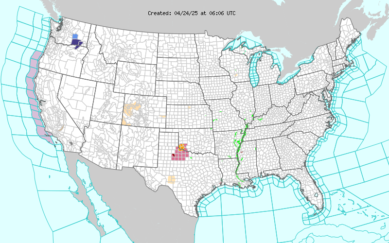
Map of the Current Watches, Warnings, and Advisories Nationwide:
|
|
Member of the:


|
North Valley Random Weather Facts |
HUMIDITY
Humidity or relative humidity measures the amount of water vapor in the air relative to the temperature. It is important in weather because humidity affects how humans feel. A hot, humid day feels hotter because we cannot sweat as effectively. A cool, dry day feels colder because moisture evaporates more easily.
Get the Facts PHP
|
|
Page layout last updated on Mar 8th, 2024
|
|
|


 New Feature