Welcome to the Pepper Ridge North Valley's
Severe Weather Page
This is your weather warning resource page. Check this page for the latest watches and warning updates,
from The National Weather Service, Phoenix, Az.!
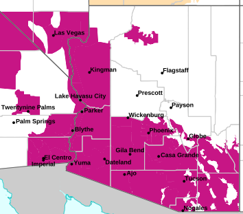
MAP OF CURRENT SOUTHWEST WATCHES, WARNINGS AND ADVISORIES
Local & Regional Weather Statements, Watches And Warnings
Weather Alerts for Pinal CountyIssued by the National Weather Service |
 FLOOD ADVISORY |
| PINAL COUNTY |
Areas Affected:
Gila, AZ - Pinal, AZ |
| Effective: Sun, 11/1 2:56am |
Updated: Sun, 11/1 3:11am |
Urgency: Expected |
| Expires: Sun, 11/1 7:00am |
Severity: Minor |
Certainty: Likely |
|
Details:
* WHAT...Flooding caused by excessive rainfall is expected.

* WHERE...Gila County in east central Arizona...
Pinal County in southeastern Arizona...

* WHEN...Until 700 AM MST.

* IMPACTS...Minor flooding in low-lying and poor drainage areas.
Rises in small streams and normally dry arroyos.

* ADDITIONAL DETAILS...
- At 256 AM MST, Doppler radar and automated rain gauges indicated
moderate to at times heavy rain in the warned area. Minor
flooding is ongoing or expected to begin shortly in the advisory
area. Between 0.5 and 2 inches of rain have fallen over the last
6 hours.
- Additional rainfall amounts of 0.5 to 1.5 inches are expected
within portions of the area over the next several hours. This
additional rain will result in minor flooding.
- Some locations that will experience flooding include...
Globe, Superior, Miami, Top Of The World, Top-Of-The-World,
Claypool, Central Heights-Midland City, Boyce Thompson Arboretum
and Inspiration.
- http://www.weather.gov/safety/flood
Information:
Turn around, don't drown when encountering flooded roads. Most flood
deaths occur in vehicles.

Be especially cautious at night when it is harder to recognize the
dangers of flooding.

Please report observed flooding to local emergency services or law
enforcement and request they pass this information to the National
Weather Service when you can do so safely. |
 FLOOD WATCH |
| PINAL COUNTY |
Areas Affected:
Tohono O'odham Nation including Sells - Upper Santa Cruz River and Altar Valleys including Nogales - Tucson Metro Area including Tucson/Green Valley/Marana/Vail - South Central Pinal County including Eloy/Picacho Peak State Park - Southeast Pinal County including Kearny/Mammoth/Oracle - Upper Gila River and Aravaipa Valleys including Clifton/Safford - White Mountains of Graham and Greenlee Counties including Hannagan Meadow - Galiuro and Pinaleno Mountains including Mount Graham - Santa Catalina and Rincon Mountains including Mount Lemmon/Summerhaven - Baboquivari Mountains including Kitt Peak |
| Effective: Sat, 10/31 2:52pm |
Updated: Sun, 11/1 3:11am |
Urgency: Future |
| Expires: Sun, 11/1 5:00am |
Severity: Severe |
Certainty: Possible |
|
Details:
* WHAT...Flooding caused by excessive rainfall is possible.

* WHERE...A portion of Southeast Arizona, including the following
areas, Baboquivari Mountains, Catalina and Rincon Mountains,
Galiuro and Pinaleno Mountains, South Central Pinal County,
Southeast Pinal County, Tohono O'odham Nation, Tucson Metro Area,
Upper Gila River Valley, Upper Santa Cruz River Valley/Altar Valley
and White Mountains of Graham and Greenlee Counties.

* WHEN...From 11 PM MST this evening through late Sunday night.

* IMPACTS...Excessive runoff may result in flooding of rivers,
creeks, streams, and other low-lying and flood-prone locations.
Flooding may occur in poor drainage and urban areas. Low-water
crossings may be flooded.

* ADDITIONAL DETAILS...
- A strong weather system approaching the area will bring
widespread to numerous showers Sunday. Moderate to locally heavy
rainfall with rainfall totals 0.5 to 1.75 inches possible in the
valleys and 1 to 3+ inches possible in the mountains.
- http://www.weather.gov/safety/flood
Information:
You should monitor later forecasts and be alert for possible Flood
Warnings. Those living in areas prone to flooding should be prepared
to take action should flooding develop. |
| FLOOD WATCH |
| PINAL COUNTY |
Areas Affected:
New River Mesa - Rio Verde/Salt River - Superior - Tonto Basin - Mazatzal Mountains - Pinal/Superstition Mountains - San Carlos - Dripping Springs - Globe/Miami - Southeast Gila County |
| Effective: Sun, 11/1 12:41am |
Updated: Sun, 11/1 3:11am |
Urgency: Future |
| Expires: Sun, 11/1 3:00pm |
Severity: Severe |
Certainty: Possible |
|
Details:
* WHAT...Flash flooding caused by excessive rainfall continues to be
possible.

* WHERE...A portion of south central Arizona, including mainly
Southern Gila County.

* WHEN...Through late tonight.

* IMPACTS...Excessive runoff may result in flooding of rivers,
creeks, streams, and other low-lying and flood-prone locations.
Low-water crossings may be flooded.

* ADDITIONAL DETAILS...
- An atmospheric river ahead of a weather system will continue to
bring well above normal moisture to the region through today and
lead to a prolonged period of light to moderate rainfall across
the Watch area. Embedded convection will produce pockets of
heavier rain. Additional rainfall amounts, on the order of 2-4+",
through the course of Sunday on top of already moist soils, will
lead to additional runoff. Runoff in major streams, creeks, and
rivers may persist through the first half of the week.
- http://www.weather.gov/safety/flood
Information:
You should monitor later forecasts and be prepared to take action
should Flash Flood Warnings be issued. |
| FLOOD WATCH |
| PINAL COUNTY |
Areas Affected:
Aguila Valley - Northwest Valley - Tonopah Desert - Gila Bend - Buckeye/Avondale - Cave Creek/New River - Deer Valley - Central Phoenix - North Phoenix/Glendale - Scottsdale/Paradise Valley - East Valley - Fountain Hills/East Mesa - South Mountain/Ahwatukee - Southeast Valley/Queen Creek - Northwest Pinal County - West Pinal County - Apache Junction/Gold Canyon - Sonoran Desert Natl Monument |
| Effective: Sun, 11/1 12:41am |
Updated: Sun, 11/1 3:11am |
Urgency: Future |
| Expires: Sun, 11/1 3:00pm |
Severity: Severe |
Certainty: Possible |
|
Details:
* WHAT...Flash flooding caused by excessive rainfall continues to be
possible.

* WHERE...A portion of south central Arizona, including the following
areas, Phoenix Metro, rural areas of Maricopa County, and Northwest
Pinal County.

* WHEN...Through late tonight.

* IMPACTS...Excessive runoff may result in flooding of rivers,
creeks, streams, and other low-lying and flood-prone locations.
Low-water crossings may be flooded.

* ADDITIONAL DETAILS...
- An atmospheric river ahead of a weather system will continue to
bring well above normal moisture to the region through today and
lead to a prolonged period of light to moderate rainfall across
the Watch area. Embedded convection will produce pockets of
heavier rain. Additional rainfall amounts, on the order of 1-2",
through the course of Sunday on top of already moist soils, will
lead to additional runoff. Runoff in major streams, creeks, and
rivers may persist through the first half of the week.
- http://www.weather.gov/safety/flood
Information:
You should monitor later forecasts and be prepared to take action
should Flash Flood Warnings be issued. |
Key to Icons for Local & Regional Weather Statements, Watches And Warnings

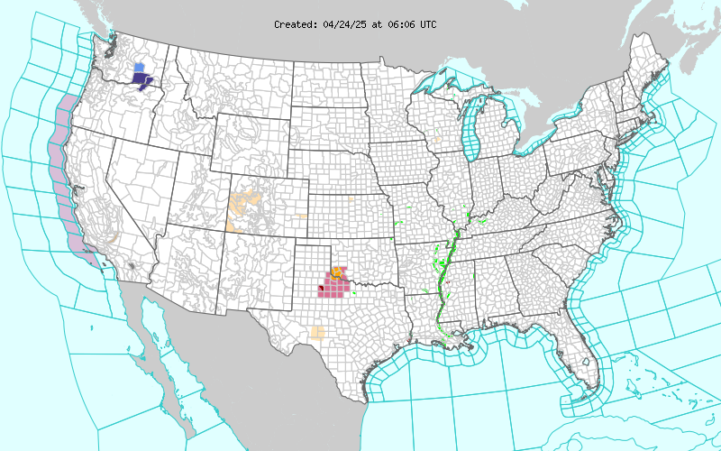
Map of the Current Watches, Warnings, and Advisories Nationwide:
|
|
Member of the:


|
North Valley Random Weather Facts |
HEAT INDEX
The Heat Index (HI) (or apparent temperature) is a measure of relative discomfort due to combined heat and high humidity. It was developed by R.G. Steadman (1979) and is based on physiological studies of evaporative skin cooling for various combinations of ambient temperature and humidity. As temperatures climb above 90 °F and humidity goes above 40 percent, conditions are ripe for heat-related illnesses.
Get the Facts PHP
|
|
Page layout last updated on Mar 8th, 2024
|
|
|


 New Feature