Skip to main content.
Currently:86.1°F Night time, Dry, Clear skies
Night time, Dry, Clear skies
Comfort Index: ---
 Updated19-Jun-2026 1:25am @ 
 
Time of Next Full Update: 1:30 am -  Station Elev: 1469 ft  
Pepper Ridge North Valley - SWN Navigation Menu
Pepper Ridge North Valley - Main Naviagation Menu

Weather Links:

       Home Page 

      Current Weather 

           Forecast Page 

          Historical Data

           Live Lightning 

            Monsoon Info 

        Satellite/Radar 

       Station Info

     Tropical Weather

        Weather Ed. 101 

          Weather Links 

      Weather Photos 

  Weather Warnings

       More Wthr Links 

Us Flag

New FeatureNew Feature
N.O.A.A Radio

Celebrating
20 Years on the web
2005 - 2025

& 25+ Years of Data
1997 - 2025
At Pepper Ridge

 Weather Reports: 
Monsoon 2025New Feature
 Highlights. 

Monsoon 2024
 Highlights. 

Monsoon 2025New Feature
 Wrap Up Review. 

Monsoon 2021
 Wrap Up Review. 


Side Bar Php

Current Conditions

@ 19-Jun-2026 1:25am
86.1°F Colder 2.5°F than last hour.
Temp Change: °F /hr
Night time, Dry, Clear skies  Night time, Dry, Clear skies
Feels Like: 83 °F
Humidity: 27%Increased 2% since last hour.
Dew Point: 48.2 °FDecreased 0.1°F since last hour.
Wind: Calm
---

 mph
Gust: 0.0 mph
Pressure: 29.75 in Rising 0.008 inHg/hour
Steady
Solar Rad: 0%
0 W/m2
UV Index: 0.0
None
Rain Today: 0.00 in
Rain Rate: 0.000 in
Rain Month: 0.00 in
Rain Year: 0.72 in

Almanac

Sunrise: 5:17 am
Sunset: 7:41 pm
Moonrise: 10:22 am
Moonset: 11:03 pm
Waxing Crescent Moon
Waxing Crescent Moon, Moon age: 4 days,11 hours,22 minutes,21%
21%
Illuminated

Daily Min/Max

Today's High Temp: 89.6°F
12:00am
Today's Low Temp: 86.1°F
1:22am
Today's High Humidity: 27%
1:16am
Today's Low Humidity: 24%
12:00am
Today's High Dewpoint: 48.6°F
12:46am
Today's Low Dewpoint: 47.2°F
12:25am
Today's High Barometric Pressure: 29.750 in/Hg
12:43am
Today's Low Barometric Pressure: 29.736 in/Hg
12:17am
Today's High Wind Speed: 0.0 mph
12:09am
Today's
High UV:
0.0
None
12:00am
Today's
High Solar:
0 W/m2
12:00am
Today's High Rain Rate: 0.000 in/min
2:00pm
Today's High
Hourly Rain Rate:
0.000 in/hr
Days Since
Last Rain:
100 Days

Current NWS Alerts:


Big Island South
  Details for Big Island South High Surf Advisory
Kailua/Kona & Kohala
  Details for Kailua/Kona & Kohala High Surf Advisory
Kauai South
  Details for Kauai South High Surf Advisory
Maui Leeward
  Details for Maui Leeward High Surf Advisory
Maui Upcountry
  Details for Maui Upcountry High Surf Advisory
Haleakala Leeward/South
  Details for Haleakala Leeward/South High Surf Advisory
Molokai South/Leeward
  Details for Molokai South/Leeward High Surf Advisory
Honolulu Metro
  Details for Honolulu Metro High Surf Advisory
Waianae Coast & Mtns, Oahu
  Details for Waianae Coast & Mtns, Oahu High Surf Advisory

Lower Sidebar Page
Pepper Ridge Weather Station
USA Weather Finder
Wunderground

Sky Warn

CWOP 3794 Quality Control Logo
CW 3794

For more information
about this site
contact the
Web Master

Willow Fire Pyro Cumulus Cloud

Return to Top
of Page

Welcome to Pepperridge North Valley's
Hawaiian Earthquakes Page

ALOHA! Welcome to Paradise!

Enjoy These Photos from Hawaii - Click on picture for full Size View!

Byodo-In Temple in Kaneohe - Oahu
Byodo-In Temple in Kãne‘ohe - Oahu, Hi


Makapu'u Lighthouse - Oahu
Makapu'u Point Lighthouse - Oahu, Hi

All Photos are © 2005- 2024 by J. Summers & The Pepper Ridge North Valley Weather Station
All rights reserved. Unauthorized duplication or distribution is prohibited


Current Reported Earthquakes from Around the Hawaiian Islands

Hawaii Quakes Page for quake-json2.php

Kaneohe Hawaii Nearby Earthquakes

Earthquakes in the past 7 days of magnitude 2.0 or greater within 350 mi
Update time = Thu, 2026-06-18 22:29:47 HST

Epicenter Near Magnitude Distance to Epicenter Time Link
17 km ENE of PÄhala, Hawaii 2.3 000352219 mi 1781831931Thu, 2026-06-18 15:18:51 HST map
4 km SSW of PÄhala, Hawaii 2.1 000348216 mi 1781821740Thu, 2026-06-18 12:29:00 HST map
13 km ENE of PÄhala, Hawaii 2.2 000353219 mi 1781818045Thu, 2026-06-18 11:27:25 HST map
15 km ENE of PÄhala, Hawaii 2.7 000352219 mi 1781798208Thu, 2026-06-18 05:56:48 HST map
12 km SSE of Fern Forest, Hawaii 2.2 000365227 mi 1781786947Thu, 2026-06-18 02:49:07 HST map
13 km SSW of Honoka‘a, Hawaii 2.8 000289180 mi 1781784705Thu, 2026-06-18 02:11:45 HST map
20 km NE of Honaunau-Napoopoo, Hawaii 2.2 000296184 mi 1781750480Wed, 2026-06-17 16:41:20 HST map
15 km E of Naalehu, Hawaii 2.1 000362225 mi 1781748646Wed, 2026-06-17 16:10:46 HST map
11 km ESE of Naalehu, Hawaii 2.1 000359223 mi 1781748358Wed, 2026-06-17 16:05:58 HST map
12 km ESE of PÄhala, Hawaii 2.0 000357222 mi 1781741386Wed, 2026-06-17 14:09:46 HST map
12 km SE of PÄhala, Hawaii 2.0 000359223 mi 1781738738Wed, 2026-06-17 13:25:38 HST map
26 km E of Honaunau-Napoopoo, Hawaii 2.0 000315196 mi 1781718567Wed, 2026-06-17 07:49:27 HST map
21 km SE of PÄhala, Hawaii 2.0 000367228 mi 1781708997Wed, 2026-06-17 05:09:57 HST map
21 km SE of PÄhala, Hawaii 2.1 000368228 mi 1781701272Wed, 2026-06-17 03:01:12 HST map
22 km SE of PÄhala, Hawaii 2.1 000368229 mi 1781700065Wed, 2026-06-17 02:41:05 HST map
17 km SE of PÄhala, Hawaii 4.5 000363226 mi 1781698469Wed, 2026-06-17 02:14:29 HST map
0 km W of PÄhala, Hawaii 2.1 000346215 mi 1781695050Wed, 2026-06-17 01:17:30 HST map
20 km SE of PÄhala, Hawaii 2.0 000367228 mi 1781693267Wed, 2026-06-17 00:47:47 HST map
19 km SE of PÄhala, Hawaii 2.3 000366227 mi 1781692941Wed, 2026-06-17 00:42:21 HST map
18 km SE of PÄhala, Hawaii 2.2 000365227 mi 1781690892Wed, 2026-06-17 00:08:12 HST map
10 km SE of PÄhala, Hawaii 2.2 000357222 mi 1781679544Tue, 2026-06-16 20:59:04 HST map
6 km SW of PÄhala, Hawaii 2.6 000348216 mi 1781679201Tue, 2026-06-16 20:53:21 HST map
21 km SSE of PÄhala, Hawaii 2.1 000367228 mi 1781661316Tue, 2026-06-16 15:55:16 HST map
21 km NNW of Wai‘Åhinu, Hawaii 2.0 000328204 mi 1781648205Tue, 2026-06-16 12:16:45 HST map
9 km SSE of Pa‘auilo, Hawaii 2.1 000303188 mi 1781629577Tue, 2026-06-16 07:06:17 HST map
7 km ENE of Pa‘auilo, Hawaii 2.8 000302188 mi 1781621683Tue, 2026-06-16 04:54:43 HST map
4 km SSW of PÄhala, Hawaii 2.3 000348216 mi 1781621327Tue, 2026-06-16 04:48:47 HST map
24 km E of Honaunau-Napoopoo, Hawaii 2.0 000312194 mi 1781613209Tue, 2026-06-16 02:33:29 HST map
15 km E of Honaunau-Napoopoo, Hawaii 2.2 000309192 mi 1781600961Mon, 2026-06-15 23:09:21 HST map
9 km NW of PÄhala, Hawaii 2.0 000337209 mi 1781593266Mon, 2026-06-15 21:01:06 HST map
24 km E of Honaunau-Napoopoo, Hawaii 2.1 000312194 mi 1781586441Mon, 2026-06-15 19:07:21 HST map
23 km E of Honaunau-Napoopoo, Hawaii 2.4 000316196 mi 1781581217Mon, 2026-06-15 17:40:17 HST map
6 km SW of Volcano, Hawaii 2.4 000347215 mi 1781476493Sun, 2026-06-14 12:34:53 HST map
31 km WNW of Hawaiian Ocean View, Hawaii 2.4 000309192 mi 1781473939Sun, 2026-06-14 11:52:19 HST map
8 km S of Honaunau-Napoopoo, Hawaii 2.8 000305189 mi 1781471774Sun, 2026-06-14 11:16:14 HST map
15 km S of Fern Forest, Hawaii 2.1 000363226 mi 1781463950Sun, 2026-06-14 09:05:50 HST map
12 km S of Honaunau-Napoopoo, Hawaii 2.4 000306190 mi 1781463670Sun, 2026-06-14 09:01:10 HST map
12 km NNE of PÄhala, Hawaii 2.0 000341212 mi 1781450880Sun, 2026-06-14 05:28:00 HST map
18 km S of Volcano, Hawaii 2.0 000361225 mi 1781408133Sat, 2026-06-13 17:35:33 HST map
4 km SW of PÄhala, Hawaii 2.6 000347215 mi 1781361412Sat, 2026-06-13 04:36:52 HST map
6 km W of Kahaluu-Keauhou, Hawaii 3.1 000277172 mi 1781336898Fri, 2026-06-12 21:48:18 HST map
19 km SSE of PÄhala, Hawaii 2.0 000366227 mi 1781332641Fri, 2026-06-12 20:37:21 HST map
21 km N of Hawaiian Ocean View, Hawaii 2.2 000320199 mi 1781279980Fri, 2026-06-12 05:59:40 HST map

43 earthquakes found. Click on location or map links for more details from the USGS

Script by Saratoga-weather.org

Map and data courtesy of United States Geological Survey.

The majority of Earthquakes in Hawaii are centered in and around "The Big Island", Hawaii and are mainly the result of the volcanic activity of the Kilauea Crater and Mauna Loa Volcanos. Earthquakes are less frequent on the other isles. You can check out the latest volcanic activity at Kilauea on our Hawaiian Volcanos Activity Page.


Current Reported Watches, Warnings and Advisiories for Oahu's Eastern Windward Shores


The latest Information of Earthquake Triggered Tsunami's


   Logo: Tsunami Evacuation Sign   Logo: Tsunami Evacuation Route Sign

What Is A Tsunami?

Tsunami (soo-NAH-mee): a Japanese word that means harbor wave; a sea wave of local or distant origin that results from large-scale seafloor displacements associated with large earthquakes, major submarine slides, or exploding volcanic islands. Typically generated by seismic or volcanic activity or by underwater landslides, a tsunami consists of a series of high-energy waves that radiate outward like pond ripples from the area in which the generating event occurred.

Not all earthquakes produce tsunamis. To generate a tsunami, an earthquake must occur underneath or near the ocean, be very large (approximately Richter magnitude 7 or greater), and create vertical movement of the sea floor. However, recent studies regarding the potential for a great Cascadia Subduction zone earthquake off the Washington, Oregon, and Northern California coastlines indicate the local tsunami waves may reach nearby coastal communities within minutes of the earthquake thereby giving little or no time to issue warnings.


How will I know if a Tsunami is coming?

The West Coast/Alaska Tsunami Warning Center (WC/ATWC) is responsible for tsunami warnings for California, Oregon, Washington, British Columbia and Alaska.
The Pacific Tsunami Warning Center (PTWC) provides warnings to international authorities, Hawaii, and U.S. Territories within the Pacific Basin.

The WC/ATWC and PTWC may issue the following bulletins:

  • Information:  A message with information about an earthquake that is not expected to generate a tsunami.
  • Advisory:  An earthquake has occurred in the Pacific Basin, which might generate a tsunami.
  • Watch:  A tsunami was or may have been generated, but is at least two hours travel time to the area in Watch status.
  • Warning:  A tsunami was, or may have been generated, which could cause damage; therefore, people in the warned area are strongly advised to evacuate.
  • A warning siren may sound.
  • Seawater may recede quickly.
  • The ground may shake, indicating an earthquake has occurred.
  • Your NOAA Tone Alert radio issues a warning that a tsunami may be headed to your area.
  • Sign up for free Email and Text Mesage Tsunami Alerts from the Pacific Tsunami Warning Center

Tsunami Evacuation Maps

Additional information on evacation routes for Hawai'i can be found at the following link; Hawai'i Evacuation routes.


Please Visit our other Hawaiian Pages: Hawaiian Tsunami Info Page ·  Hawaiian Volcanos Activity Page ·  Hawaiian Weather Page


Kãne‘ohe and Kãne‘ohe Bay with the Koolau Mountains as backdrop - Windward - Oahu, Hawaii

Kaneohe and Kaneohe Bay - Oahu, Hi


Member of the:
LightningRing
World Weather Websites

 Pepper Ridge North Valley Random Weather Facts
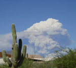
MONSOON
The best example of a monsoon on Earth occurs over the Indian sub continent. During the months of April through October, a moist southwest wind brings heavy rains to this region...while a dry northeast wind is prevalent during the remainder of the year.

In North America, a similar situation occurs over much of Mexico. For example, in Acapulco, rainfall averages 51.8 inches during the months of June through October...while only 3.3 inches falls during the remainder of the year.

In the United States, Arizona and New Mexico are located on the northern fringe of the Mexican Monsoon. For most of the year, winds aloft over the southwest U.S. are west to northwest. During the summer, winds turn to a more south to southeast direction, importing moisture from the Pacific Ocean, the Gulf of California and the Gulf of Mexico.

Get the Facts PHP


Page layout last updated on Feb 20th, 2010