Forecast Discussion for PSR NWS Office
756
FXUS65 KPSR 190513
AFDPSR
Area Forecast Discussion
National Weather Service Phoenix AZ
1013 PM MST Thu Jun 18 2026
.UPDATE...Updated 06z Aviation Discussion...
&&
.KEY MESSAGES...
- Temperatures will continue to cool closer to normal for the
remainder of the week allowing moderate HeatRisk to be reduced
towards a minor category.
- An approaching east Pacific weather disturbance will dry out the
region, while bringing increasingly breezy conditions through
the weekend which will pose in an elevated fire risk.
- Strong high pressure should build back into the region by the
middle of next week with increased odds of major HeatRisk
impacting the area.
&&
.SHORT TERM /Today through Friday/...
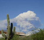
Latest mid-lvl wv imagery and 500 mb streamline analysis reveals a
weak area of low pressure embedded in a large scale ridge situated
over the western CONUS. This area of low pressure has been ever so
slowly progressing ewd over the past 1-2 days resulting in ample
moisture advection into the lower deserts of AZ. This afternoon, dry
west to southwesterly flow has become established over much of our
forecast area as noted by PWAT values falling below 1.00" across the
lower deserts. A sliver of mid-lvl moisture along with orographic
ascent over eastern AZ into the Rim Country will maintain the
potential for isolated convection through early this evening. Most
storms should remain outside of our CWA boarder, however an
isolated storm or two could develop in far E Gila County. H5
heights will change very little over the next 24 hours, however
noticeable cooling in the H8-H7 layer and wider diurnal spreads
due to markedly drier air surging into the region will result in
temperatures retreating very near the daily normals by Friday. Due
to further drying on Friday, even mountain cumulus development
will be completely eliminated.
&&
.LONG TERM /Saturday through Wednesday/...
Ensemble member agreement remains very good through early next week
advertising East Pacific troughing migrating inland and deamplifying
over the Rockies. This evolution will create a dry zonal flow
pattern with mixing ratios falling very close to 2-3 g/kg and total
column PWATs as low as 0.25" though Monday. Forecast confidence is
very good that temperatures will hover near normal through the
weekend before beginning a warming trend next week as subtropical
ridging builds back north. Modest height falls combined with
seasonably deep mixing depths will promote repeated chances of gusty
afternoon winds, and combined with the incoming dry airmass and
receptive, dessicated fuels, fire danger will become quite elevated.
There is growing confidence among operational and NAEFS members that
subtropical ridging will continue strengthening towards the SW Conus
during the middle of next week as mean longwave troughing is
established over the eastern US. H5 heights should easily rebound
over 594dm with the anti-cyclone center becoming positioned either
directly over Arizona or towards the international border. GEFS
membership generally keeps H5 heights under 595dm while some of the
more extreme CMC and EPS members are highlighting H5 heights 597-
600dm during the midweek period. Regardless, numerical guidance
means strongly suggest lower elevation high temperatures by the
middle of next week flirting with 115F, and it would not be
unexpected for reading to breach this level. As a result, widespread
major HeatRisk and extreme heat appears increasingly likely during
at least the Wed-Fri time frame next week.
&&
.AVIATION...Updated at 0510Z.
South Central Arizona including KPHX, KIWA, KSDL, and KDVT:
No major aviation weather concerns under clear skies can be
expected throughout the TAF period. The overall wind pattern will
follow the typical diurnal tendencies, with a period of southerly
winds late morning/early afternoon before the westerly shift. Some
afternoon/early evening gusts in the upper teens are likely to
materialize once again.
Southeast California/Southwest Arizona including KIPL and KBLH:
Gusty winds, especially at KIPL, will continue to be the main
aviation weather issue once again on Friday under clear skies.
West winds can be expected at KIPL and fluctuate between the south
and southwest at KBLH. Gusts upwards of 20-25 kts can be expected
Friday afternoon at KBLH and upwards of 25-30 kts for a period
Friday evening at KIPL.
&&
.FIRE WEATHER...
A pronounced drying trend will continue through the rest of this
week and into this weekend with terrain induced showers/storms
exiting into far eastern Arizona and New Mexico. Temperatures will
cool closer to normal on Friday and remain near normal through the
weekend. Minimum humidity levels will range from 10-20% this
afternoon, and further deteriorate into widespread single digits
over the weekend and early next week. Correspondingly, overnight
recovery will fall into a poor to fair 15-40% range. Upslope
afternoon gusts in the 20-25 mph range will be common over the
next several days yielding a widespread elevated fire danger,
however at this time, speeds appear to remain below critical
thresholds. By the middle of next week, temperatures will warm
markedly with minimum humidity levels hovering around 10-15% and
continued gusty winds yielding dangerous conditions for any
ongoing wildfires.
&&
.PSR WATCHES/WARNINGS/ADVISORIES...
AZ...None.
CA...None.
&&
$$
SHORT TERM...Salerno/18
LONG TERM...18
AVIATION...Lojero
FIRE WEATHER...Salerno/18
NWS PSR Office Area Forecast Discussion
|

 New Feature